
Michael Davias
HRTM 10m cyclic
Michael E Davias currently works under the pseudonym "Cintos Research", and is retired from a long career in Systems Analysis. Michael does research in Geospatial big data, Data Mining, Computer Graphics and Algorithms. He is interrogating the Mid Pleistocene climate transition and the accompanying, but missing, cosmic impact that generated the Australasian Tektites. The same impact is posited to be responsible for an extensive distribution of hydraulically closed oriented ovoid depressions which indicate a focus in the LP of Michigan. To support a geospatial survey of these basins, a seamless high resolution topographic model is being built. The spatial scope of the survey currently covers about 2/3 of the continental USA. The survey’s basin metrics have been assemble for over 60,000 landforms, using Google Earth for data capture.
North Country's EVTAC Arrow
by Michael Davias
The Eveleth Taconite (EVTAC) Mine on Minnesota's Mesabi Range hosts a large tailing pond, a section of which makes an artistic presentation of an arrow in this high resolution topographic model. The colors are generated in Global Mapper from USGS LiDAR elevation data using a 10 meter cyclic color ramp. The mine was the target of the class-action lawsuit portrayed in the 2005 movie "[North Country"](https://en.wikipedia.org/wiki/North_Country_(film)). Being a mine, one might expect the crime was an environmental one. It was, but the environment being trampled was the work environment of the female employees. The lawsuit depicted in the movie was the first class-action [sexual harassment lawsuit](https://en.wikipedia.org/wiki/Jenson_v._Eveleth_Taconite_Co.) in the United States. Josephine "Josey" Aimes and her 14 co-workers were awarded a $3.5 Million settlement after a 15 year battle.
earth-art - geology - history
#HRTM #USGS TNM #Cintos
Carroll Road Bays, Latta, SC, USA
by Michael Davias
Carroll Road Bays’ name is derived from the road that hugs the northern rim of the three bays at the center. Carroll is the family name of local landowners, who worked with local Indian tribes and ecologists to preserve the largest of bays at the middle of the map from destruction during the construction of an interstate highway. Instead of running down the middle of them, the road will now snake through and “only" disrupt two of them. HRTM using USGS 1m data, composed in Global Mapper and rendered elevation using perceptive color pallet cycling every 10m. Relief across map is within ~11m total (27m to 38m), as seen by the single range of colors. Artificial hill shade is applied at 20X to enhance the visualization. The bay planform here is “bayCarolina”, the most common across the Carolinas.
earth-art - elevation-topography
#HRTM #Cintos #Carolina bay #USGS TNE
HRTM of Windsor Farms residential development in Richmond, VA, bordering James River Gorge
by Michael Davias
The Windsor Farms residential area on the western side of the City of Richmond was engineered almost 100 years ago to create an English Village atmosphere on a farmstead bordering the James River Gorge. By following the natural terrain, the road system is constrained by the planform of the Carolina bay it is set within (not that anyone had heard of the concept of a "Carolina bay"). Today it is one of the most sought after locales for a home in Richmond. Composted in Global Mapper from ~900 Mb of USGS TME LiDAR Point Cloud data, it was rendered at a resolution of 50cm for this GeoTiff.
earth-art - elevation-topography - urban
Digging Cactus in Arizona
by Michael Davias
The Arizona Sonoran Copper Company’s [Cactus Mine](https://arizonasonoran.com/projects/cactus-mine-project/overview/) near Casa Grande, AZ, presents its spiral down into the Earth in this 25cm resolution high resolution topographic model. As inspiring as it is here, note that the company’s logo is indeed a spiral icon. I suspect it was inspired by the mine’s circular shape. The hole is about 280 meters deep at the time the LiDAR was flown, and has a diameter of roughly 900 meters. The elevation values are mapped here to a cyclic color palette that repeats every 10 meters. With some diligence, you can count the “blue” stripes from the bottom to the top, each step being 10 meters. The color of the water surface at the bottom of the hole is only coincidentally “blue”, as it sits at ~160 meters above sea level, a multiple of 10 meters. USGS LiDAR dataset “AZ_MaricopaPinal_2020_B20” was used to produce the image in Global Mapper, rendered as an ECW raster image.
earth-art - economic - geology
#HRTM #Cintos
HRTM of Goldsboro Ridge, a landform northeast of Goldsboro, NC
by Michael Davias
HRTM generated from NC State LiDAR point cloud datastet, composted in Global Mapper and exported as a GeoTiff at a resolution for 50 cm spatially. The cyclic color ramp repeats every 10 meters, with the relief here totaling ~18 m, from 25 m in the NE drainage to 43 m in the western ridge extent. The image demonstrates the progression of bay destruction by erosion from the west to the east as the ridge is eaten away by sheet erosion to the north and to the south. Bay rims go last. This location was the subject in 1970 of the most extensive coring operation ever attempted on Carolina bay landform: [Daniels, Gamble & Wheeler, The Goldsboro Ridge, an Enigma](http://libres.uncg.edu/ir/asu/f/SoutheasternGeology_Vol12_No03_1971_M.pdf).
earth-art - elevation-topography - geology
Sure looks like an reef
by Michael Davias
This HRTM of the St. Petersburg peninsula of Florida reveals its topography to resemble uplifted reefs. The resolution is 1 meter horizontal and ~6 cm vertical, sourced from the USGS NED FL_Peninsular_2018_D18 dataset. The color ramp employed cycles every 10 meters, and shows the entire peninsula's bare-earth topography is at less than 20 meters above sea level. The USGS and local government shareholders are motivated to generate these elevation data to assist in the identification of flood-prone areas with a high degree of fidelity.
elevation-topography - environment - geology
Terrace Remnants with imbedded Carolina bays - Reidsville, GA
by Michael Davias
Area of terrace remnants at 55-60 masl in Reidsville, GA. Imbedded Carolina bays demonstrate that most of these landforms do not have raised rims of sand dunes, but are instead simply depressions in the terrace. HRTM from USGS datasets, rendered at 150 cm spatial grid in Global Mapper using a preceptive cyclic color pallet that repeats every 10 m. Each color band becomes an effective contour line,
earth-art - elevation-topography
HRTM of Alluvial Fan from Chinati Mountains terminating at Rio Grande
by Michael Davias
HRTM generated from USGS TNM 1m DEM, composted in Global Mapper and exported as a GeoTiff at a resolution of 1m spatially. The cyclic color ramp repeats every 10 meters, with the relief of ~830 m at Rio Grande on the west to ~950 m at the top of the alluvial fan to the East. The image demonstrates that fine details on low relief areas can be visualized in regions of high relief. Location is in Chinati Mountains, Presidio, TX. An interesting anomaly (to me, anyway) is that the surface of the newest - and centermost - region of this fan actually lies ~5 meters *below* the older segment to the north and south, suggesting it is cutting into the old fan. Sign of uplift or climate change?
earth-art - elevation-topography - geology
Great Deception in Iowa
by Michael Davias
Somehow, an oxbow along the Des Moines River in Iowa has garnered the name “Deception Hollow”. It is located a few miles southeast of Lehigh, IA and now hosts a public boat launch. The stretch of the Des Moines through this area is part of Iowa’s [Des Moines River Water Trail](https://www.iowadnr.gov/Portals/idnr/uploads/riverprograms/watertrails/wt_dsmwebster.pdf), which has benefited from the recent [removal of dams ](https://www.snyder-associates.com/projects/des-moines-river-dam-removal/) in the Fort Dodge area. The HRTM was generate in Global Mapper GIS using Iowa DNR Lidar provided through the USGS 3D elevation program. 1 meter dataset IA_NorthCentral_2020_D20. The protocol used to map elevations to colors utilizes a 200-step human perceptive [color table](https://carolina-bay-survey.s3.amazonaws.com/mapfiles/kml/Elevation-ColorScaleC6.png) that cycles every 10 meters relative to sea level. This provides an intrinsic relative elevation relationship across the image, and also [adds](url) continuous sets of contour lines. If the viewer selects the Open Topography base map, the 10-meter contour lines map well to the “dark Blue” in the color table, and supply the actual elevation values.
earth-art - elevation-topography - environment
#HRTM #Cintos
Iowa Parallel Relief
by Michael Davias
HRTM meter resolution of a ~7 km long lineal just south of Readlyn, Iowa (top of map) which runs parallel to a 16 km long lineal located 6 km to the south. The town of Denver, IA is on left of map. The elevation key is a false color map that recycles every 10 meters. The protocol is employed to tickle out light elevation differences which might reveal geological formations or landforms otherwise invisible in other media. There are obvious parabolic dunes in the lower left of the image, but the main strikes are of interest. The strike runs across the NNW-SSE trend of the regional terrain fabric. The ECW imagery was rendered in Global Mapper from recently-released USGS TNM 1m dataset *IA_EasternIA_2019_B19*.
elevation-topography - geology
#HRTM #USGS TNM
Making a Mountain out of a Mown Hill
by Michael Davias
When an urban dweller mows his green carpet lawn, the clippings likely go into the local waste collection service. In Pompano Beach, Florida , that destination would be the Monarch Hill Landfill. The folks at [WM] (https://www.wm.com/us/en/location/fl/pompano-beach?utm_source=gmb&utm_medium=organic&utm_campaign=S04015) have built quite the proverbial pyramid. It was about 120 feet high when this LiDAR data was captured. This HRTM uses USGS TNM elevation data and is rendered in Global Mapper commercial GIS. The color-to elevation mapping cycles every 10 meters, so you can count the repetition os blue stripes up the side of the hill. Sea leve is a t0, 10, 20, 30 meters above sea level... The HRTM uses a 20x exaggeration when applying hill shading, making this look more of a mountain than it really is.
earth-art - environment - urban
#HRTM #Cintos
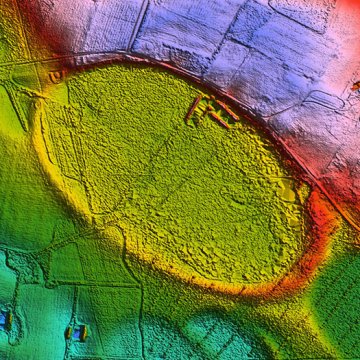
Heart of the Carolina Bays
by Michael Davias
High Resolution Topographic Model (HRTM) of a 12,000 hectare landscape at the junction of Robeson, Hoke and Scotland Counties, NC. The floor of the Heart Shaped Bay has a natural elevation of 69 meters above sea level, which would normally be purple in my general distribution survey. Here, Global Mapper’s ability to modify elevation values has been utilized to raise the elevation by 7.1 meters, putting it into the red band for the “heart” color effect. The normal cycling of colors every ten meters persist here, regardless of the offset, allowing for relative comparisons of local relief. Maximum relief differential within the imaged area is `22 meters. The Heart is roughly 3 km x 2 km in size. It has been extensively ditched and now hosts open farmland and tree plantations. The basin is considered by me to be a composite of at least three Carolina bays. Given the basins' long history as hydrologically closed, the floor has filled with many meters of organics and wind-blown sediments. Should it ever be probed by ground penetrating radar, there would likely be signs of the overlap rims under that fill.
earth-art - elevation-topography
#HRTM #Carolina bay
Playas Lakes on High Plains of Texas Panhandle Recognized for Recharge of Aquifers
by Michael Davias
HRTM rendered at 3 meters spatial resolution from 1 meter USGS NED datasets. Region imaged is ~5,100 square km on the Texas Panhandle, part of a 30,000 square km region which yielded ~7,000 playas. The elevation to color mapping is cyclic, repeating every 10 meters, providing an index to local relief (dark Blue is indexed to “xxx0”). The technique also provides an intrinsic set of contour lines. The playa of the High Plains of the USA contain over 80,000 playas by some estimates. They have been found to be the primary source of water recharging the Ogallala aquifer. Alteration or destruction of playas may be contributing to the precipitous decline in the accessible water within the Ogallala. Recent programs by organizations like the [Playa Lakes Joint Venture](https://pljv.org/playas/playa-science/) are attempting to rejuvenate them. The central zone of each playa presents as a solid color, as it is effectively a temporal wetland, all at the same level. Most playa mapping focuses on the size and shape of those footprints. But the striking aureoles which encircle them actually form the effective "basin" capturing precipitation and directing it down slope to the wetland for eventual recharging of the aquifer.
earth-art - elevation-topography
Enigmas On the Eastern Shore
by Michael Davias
The US Commonwealth of Virginia occupies a vast extent on the Atlantic coastal plain, but also claims a detached extent across the Chesapeake Bay from the mainland, on the southern extent of the DelMarva Peninsula. The land holds the colloquial name [The Eastern Shore ](https://en.wikipedia.org/wiki/Eastern_Shore_of_Virginia). Over 700 "Carolina bays" exist along the Eastern Shore's elevated spine. Although these landforms express a very shallow basin they are clearly evident in this HRTM image. The spatial footprint of these ovoid basins is often 1,500 m or more on the main axis. While most are located on the elevated portion of the peninsula, some on the north east side exhibit being inundated by the waters of the Chesapeake bay, offering but a ghostly trace of their robustly-repeatable and directionally aligned shape seen in a wide scale of sizes. The digital elevation-to-color table cycles every 10 meters, giving such low relief structures an opportunity to express their elegant and enigmatic details. The accompanying color index provides a relative elevation, modulo 10 m, with sea level at 0 m. The image was generated in Global Mapper using USGS LiDAR elevation data sampled down to a 1.2 m resolution.
earth-art - elevation-topography - geology
#HRTM #Eastern Shore #Virginia #Carolina bay
Route 2, Glacier National Park, Montana, USA
by Michael Davias
HRTM generated at 1 meter resolution, from 10 cm USGS LiDAR (MT_GlacierNP_2016). Rendered by Global Mapper as an ecw file, which results in a file that is only 20% the size of the tiff output (126 MB vs 664 MB). The LiDAR flights were specifically designed to capture the roadway and the immediate area along it. The route stretches about 85 miles between the West Glacier and East Glacier Park Village, and parallels the historic rail line which brought visitors to the region before the roads. [Amtrak's Empire Builder](https://www.lonelyplanet.com/articles/glacier-national-park-by-train) train now passes through the park regularly. The HRTM was engineered with a cyclic color ramp repeating every 10 meters. The goal is to elaborate on the fine details of the low relief areas, while dealing with the challenges of color range in areas of high relief. This dateset provides a great opportunity to test the results. A PDF with details of the LiDAR capture is available from the [USGS](https://ftpgeoinfo.msl.mt.gov/Data/Spatial/MSDI/Elevation/Lidar/Reports/FLATHEAD_2016_GNP.pdf). See more information on the park at the [NPS web site](https://www.nps.gov/glac/learn/photosmultimedia/podcasts_gtsr4.htm).
elevation-topography - geology - transport
#HRTM #Cintos #USGS TNM #Glacier National Park #Road Trip
A Little Rock layered Oxbow Cake
by Michael Davias
layers of Oxbows are a favorite treat for the scenery around Little Rock, Arkansas. The Arkansas River leaves the south eastern extent of the Ozarks at Little Rock and spill out onto the western fringes of the wide and slowly rising Mississippi River alluvial plain. Doing so it dumps a lot of sediments that have generated hundreds of oxbows as the river's channel lashes around on its way to the Mississippi. The formal word for such activity is "anastomosis", which is also applied in medicine and biology - think "by-pass surgery." Thia HRTM has been truncated to between 68 and 79 meters above sea level so as to focus just on the meandering pattern as a natural art form. Data from USGS's The National Map was processed in Global Mapper and rendered at 3 meters per pixel.
earth-art - elevation-topography - geology
#HRTM #USGS TNM #Cintos
Under, over, around & through : RailCross at Waycross
by Michael Davias
The CSX/Atlantic Coast Line Rice Railyard in Waycross, GA is the second largest rail yard in the UDSA, after Chicago's. The rail yard had its roots in the Atlantic Costal Railway back in its hayday. The infrastructure solves the problem of rerouting north<>southbond and west<>eastbound traffic with a combination of a "cloverleaf" in the north east corner of the HRTM, and the intricate fan-in/fan-out combined with a bridge at the center of the map. For a bit more background, a recent [blog post](https://towns-and-nature.blogspot.com/2021/10/waycross-ga-csxatlantic-coast-line-rice.html) by Dennis DeBruler includes some still drone photos. The HRTM was rendered in Global Mapper using [USGS TNM 1m DEM](https://rockyweb.usgs.gov/vdelivery/Datasets/Staged/Elevation/1m/Projects/GA_Statewide_2018_B18_DRRA). Due to the expansiveness of the yard, the 1m resolution will need to suffice. The source LiDAR point cloud is also available from the USGS.
earth-art - elevation-topography
The Jay and its Fort
by Michael Davias
Post is replaced with newer LiDAR, as this one was captured in 2015, when the souther end of Jay had not yet been built. This image was generated in Global Mapper using LiDAR point cloud data. The cyclic color ramp of the elevation-to-image mapping yields an unexpected apparition. [Fort Jay](https://www.nps.gov/gois/learn/historyculture/fortjay.htm) was expected, but the effigy of a Jay was not. Located on Governor's Island in New York Harbor. The reclamation of the old Army/Coast Guard base historically located there turned the fort into a National Monument, and landscape architects West 8 was engaged to convert the large expanse of the former gulf course into "The Hills", extending up to 70 feet over the harbor. The Hills offer lush rolling landscapes, grassy overlooks, exhilarating slides, unforgettable views and a permanent installation by British artist Rachel Whiteread. I have found no reference to the bird effigy structure of "The Hills", so I self named it a "Jay" after the fort. The elevation legend shows the colors used in a cyclic fashion from sea level upward, repeating every 10 meters. It is only a matter of serendipity that it is visualized so stunningly.
earth-art - environment - history
#HRTM #New York #Govenor's Island #Cintos
Don't Oxbow me!
by Michael Davias
Until today I was not aware of the Nolichucky River. The Cherokee named it "Rushing Water". It turns out it's one the most beautiful rivers in the United States. Originating in western North Carolina at the highest peak east of the Rockies(Mount Mitchell), it is considered one of the most spectacular whitewater rafting destinations in the eastern United States. It delivers its flow downstream past Erwin and Greenville Tennessee to the French Broad, a major tributary of the Tennessee River. The site of this Great Bend in the Nolichucky is about 6 kilometers downstream from Erwin. Although the bend's neck is surprisingly slender - about 170 meters wide at its thinnest - the height and competent bedrock of the divide suggests an abandoned oxbow lake will not be forming here anytime soon. The HRTM is derived from USGS LiDAR dataset LPC_TN_Eastern_TN_LiDAR_2016_B16. It was down sampled and rendered at 25 cm resolution in Global Mapper. The color to elevation mapping was done using a 10 m cyclic color palette, which provides an intrinsic set of contour lines. One byproduct is the clarity of any flat surface, such as the roadway that runs across the Eastern face of the divide.
earth-art - elevation-topography - geology
Ribbons of color flowing down the Moreau
by Michael Davias
The Moreau River flows eastward across Northwest South Dakota, USA, across a previously glaciated terrain. Beginning in a North Fork and South Fork, it travels 320 km on its way to the Missouri River. The image is a high resolution topographic model created in Global Mapper using USGS LiDAR elevation data at a 1m resolution. The color ramp is designed to hi-light slight elevation changes by cycling every 10 meters.
earth-art - elevation-topography - geology
#HRTM #Cintos #USGS